CONDUCTING A SCHOOL SAFETY ASSESSMENT
ASSESS INFRASTRUCTURE SAFETY
Star Rating for Schools involves an assessment of over 30 road infrastructure attributes that are known to have an impact on both the likelihood of a crash and its severity. A rating of between 1 and 5 stars is awarded depending on the level of safety which is ‘built-in’ to the road. The safest roads (4- and 5-star) have road safety attributes that are appropriate for the prevailing traffic speeds, while the most dangerous roads (1- and 2-star) lack these fundamental facilities.
PLAN AN ASSESSMENT

In preparation for the assessments, a team for data collection with good technical skills and preferably experienced on SR4S data collection or supervised by a skilled data collector must be identified. The team must receive proper training before undertaking the assessments (see the “Building Capacity on Assessments” section for more details).
To proceed with the SR4S assessment, the critical locations around the school to be assessed must be identified. The number of datapoints established around the school may vary depending on the complexity of the school environment, but 3-5 locations in each school zone is usually enough. It is very important to involve the school community in the process of selecting the datapoints to be assessed as they have the necessary first-hand experience gained from regularly accessing these high-risk locations.
The roads included in a Star Rating for Schools assessment can vary depending on the available resources, school location, surrounding road network conditions, crash history and any interaction with other related projects.
For projects where the focus is to quickly identify high-risk sites and apply low-cost countermeasures to promptly improve safety, then a focus on immediate school boundary roads and nearby high volume and high-speed roads may be best.
For projects where there is the opportunity to inform broader projects, such as ‘safer routes to school’ or ‘model school zone’ projects, or broader road agency investments, then larger-scale assessments of surrounding road networks can be undertaken.
The following general guidance should be considered when determining which roads to assess. Consider including roads:
- that students and parents most commonly travel on. These can be determined through observational studies and/or surveys with the school community.
- within the school’s geographic enrolment boundaries, considering physical barriers that cannot be crossed by pedestrians such as rivers, railroads and development boundaries
- that border the school and where pedestrian flows are present
- that connect to parking areas and other designated student drop-off zones
- that connect the school with public transport stops
- within a ¼ mile (400m) radius of the school, where traffic tends to converge. A greater radius should be considered if pedestrian volumes and travel routes warrant extension of the assessment area
- that carry high pedestrian flow in the remaining catchment area
- that carry higher speed (greater than 35mph or 55 km/h) traffic and/or those with traffic volumes greater than 10,000 vehicles per day in the catchment area where pedestrians are present

IDENTIFYING ATTRACTION POINTS
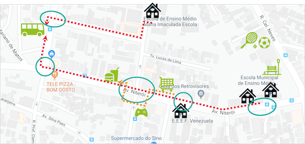
As a first step in mapping the critical locations within the school zone, it is important to understand the mobility dynamics in this area. It is helpful to map the main attraction points and facilities that may influence pedestrian routes. Consider residential access points, supermarkets, small shops, parks, bus stops etc.
MAPPING PEDESTRIAN ROUTES
Mapping the main attraction points within your school zone will make it easier to understand the main pedestrian routes around the school. Observe the sections where there is a high volume of pedestrians walking and where they cross the streets. Note that this may or may not be a formal crossing point. If pedestrians are crossing at a specific location without pedestrian crossing facilities, it may indicate lack of appropriate crossing facilities tailored to pedestrians’ desire lines and this is worth further investigation.
CRASH DATA (IF AVAILABLE)
If crash data is available, traffic crashes occurring in the area where the school is located can be cross-checked with observations on pedestrian routes and attraction points. If there are specific locations with a high incidence of crashes, especially those involving pedestrians, these are potential candidates to be datapoints that can be assessed with SR4S.
UNDERTAKE THE SR4S ASSESSMENT
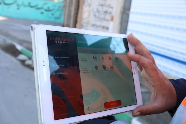
After selecting the datapoints, it is time to collect data and check the Star Ratings for each of the locations assessed. The system requires information on road infrastructure attributes, vehicle and pedestrian flow and operating speeds. The steps below describe how to start using the SR4S system:
- Create an account: access https://results.starratingforschools.org/ and select the option “Register” to create a SR4S account (For more details, see “Create an account” tutorial)
- Establish a project: enter the project information on the form “Establish a Project” (For more details, see “Establish a Project” tutorial)
- Collect data: after confirmation of the project approval, the system can be accessed, and data can be collected (For more details, see “SR4S Coding Guide”)
- Process data: once it has been collected, the user must submit the data for processing to get access to the Star Rating results (For more details, see SR4S processing guide)
QUALITY ASSURANCE
The road coding is one of the most important and demanding tasks on using SR4S. Errors can have a significant impact on the results, leading to incorrect Star Ratings. For this reason, collectors are recommended to undertake quality assurance processes. Any results intended to be published are especially sensitive and should be carefully reviewed.
For each project, a coding team with competent computer skills and good attention to detail must be designated. They should receive appropriate training on data collection and undertake the coding under the supervision of a qualified and experienced coding supervisor. Data collectors are encouraged to participate in peer and community reviews, as follows:
1) Peer review: the data is peer reviewed by colleagues or partners with coding experience. This can be done by a simple review of data collected, in which the peer reviewer reviews the coding from the data collector. Alternatively, it can be done by blind coding, in which the peer reviewer codes the same location without seeing the coding of the data collector, the results from each are then compared to check for inconsistencies.
2) Supervisor review: the supervisor, a team member experienced in coding, reviews the coding from the data collector to check for inconsistencies.
3) ViDA Forum: data collectors can ask questions and discuss coding options in the iRAP ViDA Forum. The ViDA Forum connects with iRAP members and experienced data collectors.
4) Team discussion: in the case that inconsistencies in the coding are identified, the team should discuss the best option for each of the irregularities. The final decision should be documented for future reference.
5) iRAP review before publishing: before processing data through the SR4S system and sharing the results externally, the data collector must request a formal iRAP review.


